Rivière le Rancure

Entrevennes, Vinon-sur-Verdon
  • Val de Rancure
  • Val de Rancure
Val de RancureVal de Rancure

Presentation

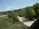
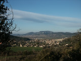
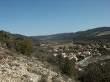
This tributary of the Durance rises in Saint-Jeannet at an altitude of 580 m. The river is 23.9 km long.
It has been dry since the early 2000s.
Opening day(s)

All year long 2026

Every day

Catégory/ies
  • Water :
    • River
  • nature miscellaneous :
    • Valley / glen
Useful Information
  • Period :
    • Autumn
    • Summer
    • Winter
    • Spring
    • Open year round

Tarifs

Free access.
Contact
Rivière le Rancure
Du Castellet à Entrevennes et Puimichel
04700
Entrevennes
Phone : +33 4 92 78 60 80
mail / message
FICHE_INFO_SIMPLE_ECRIRE_MESSAGE
Fields with an asterisk * must not be left blank
My request
Your Contact Details
In accordance with Law No. 78-17 of 6 January 1978 of the National Committee for Information Technology and Civil Liberties (CNIL) with regard to computing, files and liberties (article 36), the interested party is entitled to ask for his/her personal information to be rectified, completed, clarified, updated or deleted if it is inaccurate, incomplete, ambiguous, elapsed or in respect of which it is forbidden to use, disseminate or store said information. Should you wish to exercise this right, please specify the fact in the form above.
  • Spoken language(s) :
    • French
Destination
Rivière le Rancure
Du Castellet à Entrevennes et Puimichel
04700
Entrevennes
GPS coordinates
Latitude : 43.93648
Longitude : 6.034955